Sabtu, 04 Maret 2017

Borobudure Temple, One of 7 Wonders

b-intro 

 The Borobudur Temple Compounds is one of the greatest Buddhist monuments in the world, and was built in the 8th and 9th centuries AD during the reign of the Syailendra Dynasty. The monument is located in the Kedu Valley, in the southern part of the Central Java, at the centre of the Island of Java, Indonesia.

The main temple is a stupa built in three tiers around a hill which was a natural centre: a pyramidal base with five concentric square terraces, the trunk of a cone with three circular platforms and, at the top, a monumental stupa. The walls and balustrades are decorated with fine low reliefs, covering a total surface area of 2,520 m2. Around the circular platforms are 72 openwork stupas, each containing a statue of the Buddha.

The vertical division of Borobudur Temple into base, body, and superstructure perfectly accords with the conception of the Universe in Buddhist cosmology. It is believe that the universe is divided into three superimposing spheres. "Kamadhatu", "Rupadhatu", and "Arupadhatu", representing respectively the sphere of desires where we are bound to our desires, the sphere of form where we abandon our desires but are still bound to name and form, and the sphere of formlessness where there is no longer either name of form.

At Borobudur Temple, the "Kamadhatu" is represented by the base, the "Rupadathu" by the five square terraces, and the "Arupadhatu" by the three circular platforms as well as the big stupa. The whole structure shows a unique blending of the very central ideas of ancestor worship, related to the idea of a terraced mountain, combined with the Buddhist concept of attaining Nirvana.

The Temple should also be seen as an outstanding dynastic monument of the Syailendra Dynasty that ruled Java for around five centuries until the 10th century.

The Borobudur Temple Compounds consist of three monuments: namely the Borobudur Temple and two smaller temples situated to the east on a straight axis to Borobudur. The two temples are Mendut Temple, whose depiction of Buddha is represented by a formidable monolith accompanied by two Bodhisattvas, and Pawon Temple, a smaller temple whose inner space does not reveal which deity might have been the object of worship. Those three monuments represent phases in the attainment of Nirvana.

The temple was used as a Buddhist temple from its construction until sometime between the 10th and 15th centuries when it was abandoned. Since its re-discovery in the 19th century and restoration in the 20th century, it has been brought back into a Buddhist archaeological site.

Criterion (i): Borobudur Temples Compounds with its stepped, unroofed pyramid consisting of ten superimposing terraces, crowned by a large bell-shaped dome is a harmonious marriage of stupas, temple and mountain that is masterpiece of Buddhist architecture and monumental arts.

Criterion (ii): Borobudur Temple Compounds is an outstanding example of Indonesia's art and architecture from between the early 8th and late 9th centuries that exerted considerable influences on an architectural revival between the mid-13th and early 16th centuries.

Criterion (iv): Laid out in the forms of a lotus, the sacred flower of Buddha, Borobudur Temple Compounds is an exceptional of a blending of the very centra idea of indigenous ancestor worship and the Buddhist concept of attaining Nirvana. The ten mounting terraces of the entire structure correspon to the successive stages that the Bodhisattva has to achieve before attaining to Buddhahood.

Integrity

The boundaries contain the three temples that include the imaginary axis between them. Although the cisual links are no longer open. the dynamic function between the three monuments, Borobudur Temple, Mendut Temple, and Pawon Temple is maintained.

The main threat to the ensemble is from development that could compromise the extraordinary relationship between the main monument and its wider setting and could also effect the Outstanding Universal Value of the property. The approach to the property has to a degree already been compromised by weak development regulations.

Tourism also exert considerable pressure on the property and its hiterland. There is a growing rate of deteriorationof the building stone, the cause of which needs further research. There is also a small degree of damage caused by unsupervised visitors.

The eruption of Mount Merapi is also considered as one of the potential threats because of its deposit acidic ash as happened in 2010.

Authenticity

The original materials were used to reconstruct the temple in two phases in the 20th century: after turn of the century and more recently (1973 - 1983). Mostly original materials were used with some additions to consolidate the monument and ensure proper drainage which has not had any significant adverse impact on the value of the property. Though the present state of Borobudur Temple is the result of restorations, it retained more than enough original material when re-discovered to make a reconstruction possible.

Nowaday the property could be used as a Buddhist pilgrimage site. Its overall atmosphere is, however, to a certain degree compromised by the lack of control of commercial activities and the pressure resulting from the lack of an adequate tourism management strategy.

Protection and Management Requirements

The protection of the property is performed under Indonesian Law No. 11/2010 concerning Cultural Heritage and its surrounding cultural landscape. It is executed under a National Strategic Area and the Spatial Management Plan by he Ministry of Public Works in accordance with the Law concerning Spatial Management No. 26/2007 and Govenrment Regulation No. 26/2008 concerning National Spatial Planning and will be enforced further by another presidentian regulation the Management for the Borobudur National Strategic Area that is still being drafted by the Ministry of Public Works.

The legal and institutional framework for the effective management of the property is regulated by a Presidential Decree umber 1 Year 1992. The established zones within the World Heritage property are respectively under the resposibility of the Borobudur Heritage Conservation Office under Ministry of Education and Culture, of state-owned institute PT. Taman Wisata Candi Borobudur under the Ministry of Enterprise, and of the local government (Magelang Regency and Central Java Province). A study on the integrated management of Borobudur Temple Compunds has been conducted, including attention for the ecosystem, social and cultural aspects, ecotourism, public and private partnership and organisational feasibility study. This study is the basis of the still to be developed visitor management approach.

In order to ensure consistency between the 1992 Presidential Decree and the 1972 JICA Master Plan zone-system indicated in the World Heritage nomination dossier and to strengthen the regulations regarding development, a New Presidential Regulation is still being formulated by a Coordinating Board (14 Ministries and local authorities as well as representatives of local communities) and by formalizing the role of the proposed Management Board into the wider zones. In addition, the protection of the property has been ensured by the regular financial contribution by the national budget.

Monitoring programs has been effectively executed to monitor the growing rate of deterioration of building stone and also by unsupervised visitors. A research is being conducted to determine the long-term impact of deposit acidic ash of eruption of Mount Merapi to set further protection and conservation management of the property. Furthermore, a risk preparedness plan will be fprmulated in 2012.

The Borobudur Heritage Conservation Office has conducted community development programs targeting especially at the youth to raise their awareness. In improving and empowering local community as specialist guide for Borobudur Temple Compounds, several training programs have been conducted.

Minggu, 16 Oktober 2016

Raja Ampat, Papua Barat

Raja Ampat, Papua Barat


  Raja Ampat adalah sebuah kabupaten dengan luas wilayah lebih dari 4,5 juta hektar, dan berlokasi di sebelah barat kepala burung Papua Barat. 85% wilayah kabupaten ini merupakan lautan, sisanya merupakan pulau - pulau yang berjumlah lebih dari 600 pulau. Dari 600 pulau tersebut, terdapat 4 pulau besar, yaitu Pulau Misool, Pulau Waigeo, Pulau Batanta, dan Pulau Salawati. Selain 4 pulau tersebut, hanya 35 pulau di Kepulauan Raja Ampat yang berpenghuni, sisanya tidak ditinggali manusia. Baru sekitar 400 pulau di Kepulauan Raja Ampat sudah dieksplorasi, sisanya masih belum dijamah manusia sama sekali.

Penduduk Kepulauan Raja Ampat sebagian besar berprofesi sebagai nelayan. Mereka tinggal di kampung kecil yang terpisah dengan kampung lain karena berbeda pulau. Masyarakat kepulauan ini adalah orang yang ramah dan baik hati. Mereka mau menerima tamu dari luar dengan hati yang gembira. Penduduk Kepulauan Raja Ampat sebagian memeluk agama Kristen, dan sebagian memeluk agama Islam, namun mereka tetap rukun walau berbeda keyakinan. Saat anda berkunjung ke tempat ini sebaiknya anda membawa permen dan pinang untuk diberikan kepada mereka karena mereka menganggap barang tersebut adalah barang tanda perdamaian.

Nama Raja Ampat berasal dari cerita rakyat masyarakat setempat. Menurut cerita tersebut, ada seorang perempuan yang menemukan 7 buah telur. Telur - telur tersebut kemudian menetas, 4 diantaranya menetas menjadi pangeran, sementara 3 telur lainnya menetas menjadi seorang wanita, sebuah batu, dan hantu. 4 Pangeran tersebut kemudian menjadi raja di pulaunya masing - masing, yaitu Pulau Misool, Pulau Waigeo, Pulau Bantata, dan Pulau Salawati sehingga akhirnya disebut sebagai Raja Ampat.

Kepulauan Raja Ampat memiliki potensi wisata alam yang sangat luar biasa. Tempat wisata di Papua Barat ini sangat terkenal dengan wisata bawah lautnya yang merupakan salah satu tempat menyelam terbaik di dunia karena kelengkaoan dan keragaman flora dan fauna bawah lautnya. Berdasarkan hasil penelitian, Kepulauan Raja Ampat mempunyai 75% dari seluruh spesies karang di dunia. Tidak ada tempat lain di dunia yang mempunyai jumlah spesies karang sebanyak itu dalam 1 lokasi yang terbilang kecil. Dengan banyaknya spesies karang di Kepulauan Raja Ampat, secara otomatis juga terdapat banyak spesies ikan karang. Selain itu anda juga dapat bertemu dengan ikan pari manta, ikan duyung, kuda laut, ikan barakuda, hiu karang, penyu, tuna, dan lain - lain. Sisa - sisa perang dunia kedua juga dapat anda temui di perairan Kepulauan Raja Ampat, misalnya bangkai pesawat perang dunia di dekat Pulau Wai.

Umumnya, wisatawan yang datang berkunjung ke Kepulauan Raja Ampat adalah penyelam yang kebanyakan dari luar Indonesia. Slain wisata menyelam, bagi yang tidak bisa menyelam juga dapat menikmati pantai yang indah, wisata budaya, melihat peninggalan prasejarah berupa cap tangan, melihat festival bahari (biasanya pada bulan Agustus), menikmati panorama alam, menikmati suasana pedesaan, wisata kuliner, meilhat burung cendrawasih, mendaki bukit karang, dan lain - lain.

Anda akan dihadapi dengan 2 pilihan pada saat ingin menikmati wisata alam Kepulauan Raja Ampat. Pilihan tersebut adalah pilihan untuk tinggal di sebuah resort, atau tinggal di sebuah kapal pinisi yang sudah dimodifikasi. Kalau saran saya sih lebih baik memilih untuk menggunakan kapan pinisi, karena sudah sangat biasa tinggal di resort, sedangkan tinggal selama beberapa hari di atas sebuah kapal khas Indonesia akan menjadi pengalaman yang unik. Untuk dapat menikmati wisata Raja Ampat selama 1 minggu dengan menggunakan kapal pinisi, anda harus membayar lebih dari 100 juta rupiah, dan kapal tersebut dapat menampung sampai dengan 14 orang.

Apabila anda ingin berwisata ke Kepulauan Raja Ampat, tidak cukup hanya dengan modal nekat saja seperti yang sering dilakukan para backpacker. Berwisata ke tempat wisata yang dijuluki surga bawah laut ini membutuhkan keinginan kuat, jiwa petualang, kegemaran akan menyelam, dan modal yang lumayan besar. Bila anda berharap harga berwisata ke Kepulauan Raja Ampat akan turun dalam waktu dekat, sebaiknya buang jauh - jauh harapan anda karena sudah ada peraturan yang membatasi jumlah resort dan kapal. Hal ini bertujuan untuk menjaga kondisi alam Kepulauan Raja Ampat yang tiada duanya di dunia. Harga yang mahal tersebut juga berfungsi untuk menyaring pengunjung, sehingga hanya pengunjung yang berkualitas dan berpendidikan saja yang datang, dengan begitu mereka akan sadar betapa pentingnya lokasi ini sebagai salah satu pusat flora dan fauna yang terlengkap di dunia.

Cara Mencapai Kepulauan Raja Ampat

Sebenarnya sekarang ini untuk mencapai Kepulauan Raja Ampat tidaklah sulit, namun akan memakan waktu yang lumayan lama dan biaya yang lumayan besar. Apabila anda berada di Jakarta, maka anda harus membeli tiket pesawat dari Jakarta ke Sorong. Penerbangan tersebut akan memakan waktu lebih dari 6 jam dan biasanya akan transit dahulu di Makassar atau Manado. Setelah tiba di Sorong, anda harus menggunakan kapal untuk mencapai Kepulauan Raja Ampat, akan memakan waktu sekitar 3 jam.

Biaya sewa kapal untuk transportasi di Kepulauan Raja Ampat lumayan mahal, agar dapat lebih menghemat biaya anda harus pergi secara berkelompok, idealnya 1 kelompok berisi 8 orang, sesuai dengan kapasitas kapal yang umum digunakan di Kepulauan Raja Ampat. Dengan begitu, anda dapat membagi biaya sewa kapal dengan grup anda dan melakukan penghematan.

Atau bila anda ingin lebih berhemat, anda dapat memilih menggunakan kapal dari Jakarta menuju Sorong dengan harga tiket hanya sekitar Rp.400,000 saja. Walau murah, cara ini akan memakan waktu sangat lama, karena anda akan berhenti di beberapa kota besar. Waktu perjalanan dengan menggunakan kapal dari Jakarta ke Sorong adalah sekitar 1 minggu.

Kamis, 06 Oktober 2016

Pulau Merah Beach, Picturesque Beach In The Edge Of Java Island

Pulau Merah Beach


 Banyuwangi, located at the most - eastern edge of Java can boast yet another world class surf sport next to the already well known G-land at Plengkung: this is Pulau Merah Beach. Pulau Merah Beach is so called since just some 100 meters to the side of the beach is a picturesque little hilly island called Pulau Merah, that is reachable on foot. This is situation is similar to the location of the island of Tanah Lot to the main island of Bali. Unlike at G-land where are found sharp coral rocks by the beach, the beach at Pulau Merah or the Red Island Beach is open sand so that it is also safe for beginner surfers.

Compared to Bali's Kuta Beach, surf here is stronger, offering large 4 meters high barrels with a length of 400 meters, ideal for surfers to try out tubing techniques. But since surf here comes in at an average of two meters height. beginners and amateur surfers alike can enjoy this beach. Whereas, the beaches at Plengkung and G-land should be ventured by professionals only.

Pulau Merah Beach was originally known as Ringin Pitu. There are two versions for its name change. One version has is because the colong of the soil and sand are reddish, this is where it got its name from, while another story says that at one time some bright red rays shone from the small hilly Puau Merah Island onto the beach, thus giving it the name Pulau Merah Beach. Another feature of the beach is the nearby fishing village called Pancer, where you can stay at villager's home. Their hospitality to visitors in spite of their simple life is truly heartwarming.

Get Around

When you wish to explore Pulau Merah Beach, head tu Pura Tawang Alun. This Hindu temple was built in 1980 and is frequented by Hindus from the East Java's Bromo mountain area as well as from Bali. Unfortunately, the 1994 tsunami destroyed the outer walls of the temple but the inner sanctuary (Palinggih Padmasana) has remained intact. During the tsunami a 13 meter wave swept across the village destroying all including parts of this temple.

During your explorations you will see people wearing bright green uniform. These are gold miners, at a mine found near the shore. Local villagers, however, are opposed to its existence here since the mine pollutes the sea.

Get There

Pulau Merah Beach is one of the many attractive beaches found along the southern coast of East Java. To reach Pulau Merah Beach, you must first fly to Banyuwangi or you can also come in through the airports of Malang or Surabaya, capital of the province of East Java. Closes airport, however, is Banyuwangi.

Located some 60KM from Banyuwangi, the beach can be reached by car or motorbike in three hours, near the village of Sumberagung, in the subdistrict of Pesanggaran. Since access roads are smooth, it has become a favorite weekend destination for Banyuwangi residents. It is advisable to hire a car at the airport of Belimbingsari since there are few public buses heading to Pulau Merah from here.

From the town of Banyuwangi you can take a bus to Ujang Jaya in the direction of Pesanggaran Village. Alight at the Pesanggaran market then continue by ojek or motorbike taxi to Pulau Merah. From Jember, alight at the Jajag terminal, and connect with the bus to Pesanggaran.

Source : http://indonesia.travel/en/destination/point-of-interest/pulau-merah-beach

Selasa, 04 Oktober 2016

The Mighty Mount Rinjani, Lombok, Indonesia

Mount Rinjani


 The Mighty Rinjani mountain of Gunung Rinjani is a massive volcano which towers over the island of Lombok. A climb to the top is one of the most exhilarating experiences you can have in Indonesia. At 3,726 meters tall, Gunung Rinjani is the second highest mountain in Indonesia. The climb to the top may not be easy but it's worth it, and is widely regarded as one of the best views in the country.

Within the mountain is a crescent shaped lake, the breathtaking Segara Anak which is a spiritual place. The Balinese come here each year and perform a ceremony to the mountain spirit. The Wetu Telu people also regard the lake as holy and come here to pray on full moon nights.This lake of sulfur is located 600 meters below the crater rim. Rising from the waters of this lake is a new volcano, Mt. Baru, which is a result of a series of eruptions the 1990's.

Mt. Rinjani lies within the Gunung Rinjani National Park. The park covers 41,330 hectares and sits inside a major bio-geographical transition zone (Wallacea). This is where the tropical flora and fauna of South East Asia meets that of Australasia. This National Park was established in 1997 and is one of over 40 throughout Indonesia.

Three-day Rinjani route from Senaru to the crater rim, down to the Crater Lake the on to Sembalun Lawang, is considered one of the best treks in South East Asia. More adventurous trekkers may want to head all the way to the summit of the volcano. This is best reached from Sembalun Lawang and takes four days, finishing up in Senaru.

Get Around

The most popular way to clim Rinjani is through a four or five days hiking expeition, starting at Senaru and finishing at Sembalun Lawang. Trekkers begin from Senaru hiking to the stunning crater rim, down to the incredible crater lake and then onto Sembalun Lawang. More information about trekking up Mt. Rinjani is available at the Rinjani trekking club website.

Get There

Senaru and Sembalun Lawang Villages are the two starting points to clim Gunung Rinjani. Senaru Village is a three hour drive north of Mataram, while Sembalun Lawang Villages is approximately a four hours drive to the east of Mataram. You can get to Senaru by taking public transport to Bayan and then walking.

Source :http://www.indonesia.travel/en/destination/point-of-interest/mount-rinjani

Minggu, 02 Oktober 2016

Pantai Pemuteran, Bali, Indonesia


Pantai Pemuteran, Bali, Indonesia

 Di bagian utara Pulau Bali, terdapat sebuah desa kecil di pinggir pantai. Semua orang menyebutnya dengan Desa Pemuteran. Desa ini dulunya adalah desa yang tandus dengan penduduk yang bermata pencaharian sebagai seorang nelayan. Di tahun 80-an, orang - orang Desa Pemuteran Bali yang bekerja sebagai nelayan selalu mencari ikan dengan merusak terumbu karang. Mereka menggunakan bom ikan untuk menangkap ikan secara masal tanpa peduli dengan lingkungan terumbu karang.

 Adalah seorang tokoh masyarakat yang bernama I Gusti Agung Prana yang mulai sadar betapa pentingnya lingkungan terumbu karang di Desa Pemuteran Bali. Beliau mulai mengajarkan masyarakat betapa pentingnya lingkungan bagi manusia terutama lingkungan di bawah laut. Berkat kerja keras beliau, perlahan - lahan masyarakat mulai sadar dengan tindakan mereka yang salah dalam menangkap ikan.

Kemudian seiring dengan berjalannya waktu, Desa Pemuteran Bali ini dikenal sebagai desa wisata yang sangat indah dan menawan. Hasil kerja keras yang tidak sia - sia dari I Gusti Agung Prana dalam memelihara lingkungan sekitar desanya.

Desa Pemuteran Bali

Berbeda halnya dengan objek wisata lainnya di Bali yang sangat riuh dengan kunjungan wisatawan yang memadati kawasan wisata seperti di Pantai Kuta atau di GWK (Garuda Wisnu Kencana). Di Desa Pemuteran, kawasan wisatanya sangatlah sepi, bukannya sepi dari wisatawan melainkan sepi dari riuhnya suasana perkotaan.

Di desa ini hanya ada beberapa tempat penginapan kecil berbentuk pondok namun memiliki halaman yang luas. Kebanyakan orang - orang yang menginap disana adalah orang - orang dari manca negara. Desa ini memiliki adat istiadat yang masih sangat kental, karena investor yang ingin membuat sebuah penginapan disana harus mentaati sebuah peraturan yang tak tertulis dalam hal pembangunan sebuah penginapan.

Bagi anda yang ingin melumpuhkan sejenak syaraf - syaraf dan otot - otot tubuh anda melalui meditasi, tempat ini merupakan tempat yang sangat tepat. Di beberapa penginapan juga menyediakan fitur meditasi bagi para pengunjungnya. Kebanyakan mereka yang bermeditasi adalah kalangan lansia yang mungkin ingin melewati masa pensiunnya di tempat - tempat yang tenang.

Untuk menuju ke tempat ini anda harus menempuh jarak sekitar 200km dari Kota Denpasar atau selama empat jam.

Rabu, 14 September 2016

Pantai Amed, Bali

Pantai Amed


  Pantai Amed Bali Timur adalah keindahan alam yang mungkin anda inginkan. Inilah surga khusus dari kecantikan eksotis yang luar biasa, budaya hidup dan wajah - wajah orang yang ramah. Di sini anda  dapat menemukan kedamaian dan ketenangan, menikmati makanan yang enak dan menikmati keuntungan dari akomodasi yang nyaman dan murah.

Pantai Amed menawarkan tempat penyelaman yang sangat baik termasuk bila anda ingin belatih menyelam. Memiliki laguna yang rata dan terumbu karang cukup dengan berenang selama 5 menit untuk bisa menikmati pemandangan bawah air yang mengagumkan ini.

Lokasi ini sangat dianjurkan untuk penyelam pemula. Amed juga memiliki celah - celah batu karang yang bagus untuk dilewati saat menyelam. Kegiatan ini tidak memiliki batasan dan layak untuk semua orang. Snorkeling dan menyelam di pantai pasir hitam di sini merupakan hal yang luar biasa, jenis dan jumlah ikan di pantai ini termasuk yang terbaik di antara pantai - pantai lainnya di Bali dengan suhu airnya 28 derajat.

Pantai ini terletak di Desa Amed dan dapat ditempuh dengan perkiraan 2,5 jam perjalanan dari Denpasar dengan menggunakan mobil. Meskipun memiliki jarak tempuh yang cukup jauh keindahan Pantai Amed adalah hal yang tidak boleh anda lewatkan saat anda mengunjungi Bali, dengan hamparan pantai berpasir hitam yang membuat air menjadi sangat jernih. Apabila anda mengunjungi pantai ini pada pagi hari, anda akan dimanjakan dengan pemandangan matahari terbit yang sangat indah.

Selain menikmati keindahan lautnya, di Pantai Amed anda dapat berjalan kaki dan menikmati pemandangan Desa Amed. Tersedia juga pasar ikan di pagi hari bagi anda yang ingin membeli ikan tuna yang baru saja diambil dari laut. Selain itu, anda juga dapat berbelanja berbagai produk laut yang terbuat dari kerang, karang, dan lainnya.

  • Source : http://pesonaindonesia.travel/D/DES/20160725012922/0/0.html
  • http://www.anythingbali.com/pantai-amed-dan-berbagai-keindahannya/

Jumat, 27 Mei 2016

Trunyan, The Death Village

In death we are equal. But there is a place in northern Bali where what follows sets it apart from the world. A dark place, home to an ancient people with an equally dark reputation, where you can literally stare death in the face.

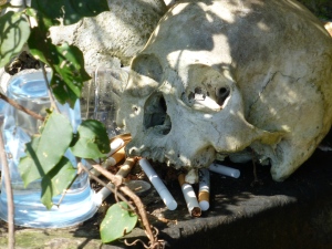
 In Trunyan there is neither burial nor cremation. The dead are taken from the village by boat to a small clearing around the cove. Bodies are partially covered with a thin white cloth, placed under a fragile bamboo cage and simply left. The cadaver is at the mercy of nature and the elements. It is ravaged, rots and decomposes until just the skeleton remains.

Only 11 bodies can lay there. When the space is needed skulls are removed and placed trophy - like on stone shelves. The rest of the bones are discarded, often just casually tossed on the fringes of the clearing. To the Bali Aga, or Original Balinese, all that matters is the souls and that has long since departed.

The people are the aborigines of Bali. Now they account for only two percent of the population. They were usurped by the Hindu - Javanese who came to the island in the 13th century and flourished. The Bali Aga retreated phisically and mentally into isolated communities and remain a breed apart.

P1000235c

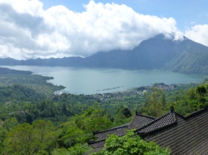
Trunyan itself sits on the eastern side of the mighty crater lake across from Batur Mount, an active volcano. A rock wall rises sheer behind the village. Beyond that is Agung Mount, Bali's highest mountain and a home to the Gods. The Batur caldera is undestandably popular with tourist but only a sparse few venture around the lake to Trunyan. The village's contradiction is to have an ugly reputation while all around is great natural beauty.

Until compartively recently the only way in was to hire oarsmen to row you across the lake. There are legendary tales of the boatmen stopping half way and threatening startled tourist if they didn't pay a hugely inflated price. For those that made it to Trunyan they were often confronted by aggressive begging, exorbitant prices and an intimidating atmosphere.

 A couple of years ago a narrow, potholed and twisting road was opened around the lake. The Bali Aga asked the Indonesian tourism authoritiesfor helpin promoting the village to tourist. Strict promises to change their ways were demanded in return. Prices were to be fixed and transparent and visitors were not to be harmed. Trunyan actually has three cemeteries.

The First, Sema Bantas, is for people who died unnatural deaths. Here, bodies are buried in unmarked shallow graves but without ceremony. The Second was the "baby cemetery", Sema Nguda. A place for the young and the unmarried of any age. Finally, Sema Wayah, the cemetery for which Trunyan is known.

The cemetery is in small clearing, quitnesses is all pervasive. For all the expectation of what cemetery experience would be like the anticipation was more disturbing than the reality. The absence of a new corpse with flesh also helped. As did the remarkable fact that the cemetery never has the smell of death. A giant 'Taru Menyan' tree, from which the villages takes it's name, stands in the corner, it's sweet fragrance and its thick, spreading roots are believed to counter the odours. Around the cove the 'Baby Cemetery' in not blessed with a similar tree.

Trunyan is a fascinating place and the Bali Aga are truly different. The villagers of Trunyan have realised that their traditional play directly to our Western fears of death and the macabre. Their naivety there is a danger that they will turn Trunyan into a kind of 'Disney of Death'.

P1000316

Source:
https://thenony.wordpress.com/